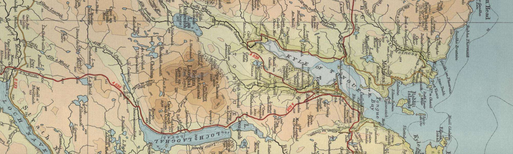
Trout Fishing at Tongue
Tongue is an attractive village on thee north Sutherland coast standing above the Kyle of Tongue, with some imposing stone buildings. Views from the village are dominated by Ben Loyal to the south and by Castle Varrich and the lovely Kyle of Tongue to the west. In 1971 a bridge and causeway replaced the narrow road that makes its way around the southern end of the Kyle. The name Tongue has its origins in Old Norse, from “tunga” or tongue of land projecting into the loch, the Norse probably living here between the 900 and 1200 AD. They may have built Castle Varrich, a small tower on the summit of a bluff overlooking the Kyle of Tongue just to the west of the village. Some believe it was built as recently as the 16th Century, by either the Bishops of Caithness or by the Mackay family. The local Tongue Angling Club has fishing on the Kyle of Tongue, which can provide some good sea trout fishing, and on a number of excellent trout lochs.

Permits are available to visitors at very reasonable rates for all the club fishing, which includes Lochs Loyal, Craggie, Hakel (Hacoln) and Chormaic. A few of the many other lochs in the area include Loch a Mhuilinn, Loch na h-Uaighe, Loch Riabhach, Loch na Beiste, Loch Fada, Loch nam Breac Buidhe, Loch Maol, Loch Craisg, Loch Modsairidh, Loch Sgeireach, Loch an Tigh Choimhid, Loch Crocach,Loch Buidhe, Loch Bealach na Sgealachd, Loch Creagach, Loch Crocach, Loch na Seilg, Loch a Ghobha Dhuibh, Loch an Dithreibh, Loch Chaluim, Loch Cuil na Sith. Enquiries for angling club permits might be made in the first instance at local shops and hotels.
Tongue Trout Fishing Map
Tap or click on the map below to view full size image

The maps on this website, extracts from the “Half Inch” Bartholomew map series of the mid twentieth century, have been reproduced with the permission of Collins Bartholomew. Viewers should note that these maps date back several decades, to the mid twentieth century in fact. While much of the man-made details such as roads and buildings will have changed over the years, the character of the hills, lochs and rivers, and the trout inhabiting them, will have remained very much the same as they have always been, in the more remote regions at any rate! This website shows detailed maps of the major fishing locations. In addition, however, I would recommend that anglers planning a Scottish fishing or walking trip should be sure to equip themselves with a compass, the appropriate local Ordnance Survey map and a working knowledge of how to use them. The most useful of the O.S. maps for the fisherman is the Landranger series, scale 1:50,000. For Tongue, see O.S. map number 10.
For information on the salmon fishing rivers in the area see Salmon Fishing in Scotland