Trout Fishing Lochs of Lochinver
It would be hard to find a better location for a trout fishing holiday than Lochinver, a fishing village situated at the mouth of the River Inver on the west coast of Sutherland. Surrounded as it is by many excellent trout lochs set in the most wild and rugged scenery of the west highlands, the whole area is a trout angler’s paradise. The fishing is run by two angling associations: The Assynt Angling Group, which controls the fishing, in the main, to the south and east of Lochinver and the Assynt Crofters Association, controlling the lochs lying to the north and west.

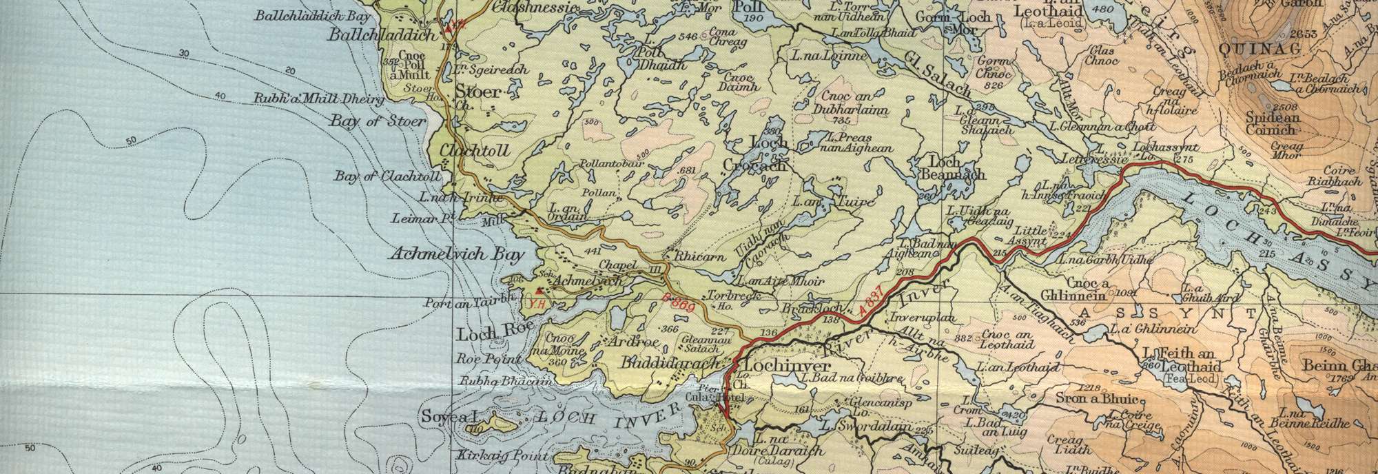
Fishing permits are readily available locally for all the lochs under both jurisdictions. Lochs in the north include Loch Poll, Loch Crocach, Loch Fraoich, Loch Drumbeg, Loch Poll Dhaidh and Loch na Claise, while the Assynt Angling Group includes Loch Assynt, Loch Beannach, Loch Fionn, Loch an Leothaid, Loch na Gainimh and many more. For a map of the Assynt area see Assynt Trout Fishing
Lochinver Trout Fishing Map
Tap or click on the map below to view full sized image

The maps on this website, extracts from the “Half Inch” Bartholomew map series of the mid twentieth century, have been reproduced with the permission of Collins Bartholomew. Viewers should note that these maps date back several decades, to the mid twentieth century in fact. While much of the man-made details such as roads and buildings will have changed over the years, the character of the hills, lochs and rivers, and the trout inhabiting them, will have remained very much the same as they have always been, in the more remote regions at any rate! This website shows detailed maps of the major fishing locations. In addition, however, I would recommend that anglers planning a Scottish fishing or walking trip should be sure to equip themselves with a compass, the appropriate local Ordnance Survey map and a working knowledge of how to use them. The most useful of the O.S. maps for the fisherman is the Landranger series, scale 1:50,000. For Lochinver, see O.S. map number 15.
For information on the salmon fishing rivers in the area see Salmon Fishing in Scotland