Trout Fishing Lochs of South Uist
South Uist is the second largest island in the Outer Hebrides, with stunningly beautiful beaches to the west and heather upland to the east. The 20 miles of machair coastline on the west, bordered by sand dunes, provides a marvellous habitat for wildlife, such as the rare Corncrake, and forms the basis for the rich trout lochs for which South Uist is famed. Salmon and sea trout fishing can be had on a variety of lochs managed by the South Uist Estates and on some of the sea pools. The estate waters can be fished out of the Lochboisdale Hotel, which has boats on seven lochs. The main machair trout lochs include Stillgarry, Grogarry, Druidibeg, Altabrug, West Ollay, Bornish and Hallan. Many of the South Uist Lochs also offer fine fishing opportunities for salmon and sea trout later in the season. These include Castle Loch, Schoolhouse, Roag, Mill Loch and Bharp. Boats on the Machair lochs may be hired at a cost of £50 per day for brown trout up to £85 per day for salmon and sea trout (two anglers per boat).
The South Uist Angling Club also offers permits, at reasonable rates, to visiting anglers for its many lochs.The fishing is at its best from June onwards. The club has boats on many of its lochs including East Bee, Duin Mhoir, Caslub, Druidibeg, A’Phuirt-ruaidh (Fraser’s), Ceann a’Bhaigh (Bayhead), Toronish, Chlachain, Eilean an Staoir, Dun na Cille. Bank fishing permits are £10 per day or £50 per week. Boats can be provided from £10 per day. Benbecula lochs include North Olabhat, East Olabhat, West Olabhat, Langabhat.
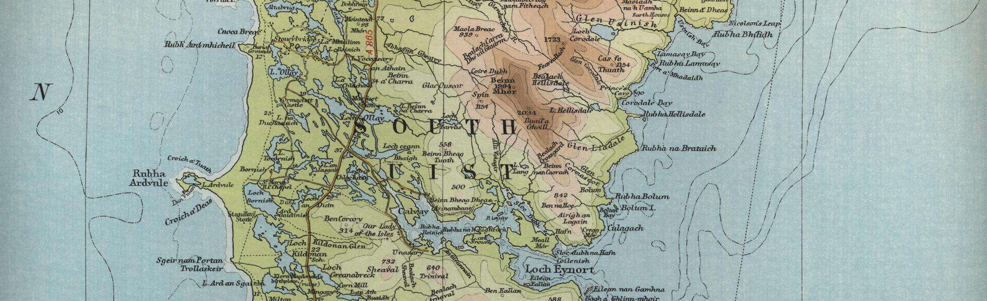
South Uist Trout Fishing Map
Tap or click on the map below to view full size image

The maps on this website, extracts from the “Half Inch” Bartholomew map series of the mid twentieth century, have been reproduced with the permission of Collins Bartholomew. Viewers should note that these maps date back several decades, to the mid twentieth century in fact. While much of the man-made details such as roads and buildings will have changed over the years, the character of the hills, lochs and rivers, and the trout inhabiting them, will have remained very much the same as they have always been, in the more remote regions at any rate! This website shows detailed maps of the major fishing locations. In addition, however, I would recommend that anglers planning a Scottish fishing or walking trip should be sure to equip themselves with a compass, the appropriate local Ordnance Survey map and a working knowledge of how to use them. The most useful of the O.S. maps for the fisherman is the Landranger series, scale 1:50,000. For South Uist, see O.S. map number 22, 31.