Trout Fishing Lochs near Gairloch
Gairloch (from the Gaelic for “Short Loch”) is one of the most popular tourist centres on the Wester Ross coast, offering many amenities and varied accommodation to the visitor. A great location, on the North Coast 500 route, for ourdoor activities, it has wonderful sandy beaches and great hill walking opportunities. Good sea fishing is on offer and excellent trout fishing on the lochs managed by Gairloch Angling Club make this a superb base for the travelling trout fisherman.

Permits for club lochs, and for salmon and sea trout fishing on the River Kerry, are available from local shops and hotels. Just a few of the trout fishing lochs to explore are Loch Maree, Fionn Loch, Loch Tollie, Loch Airidh a Phuill, Loch na Curaich, Loch Airidh Mhic Griadh, Loch an Iasgair, Loch nan Liagh and Loch a Gharbh-doire.
Gairloch Trout Fishing Map
Tap or click on the map below to view full size image

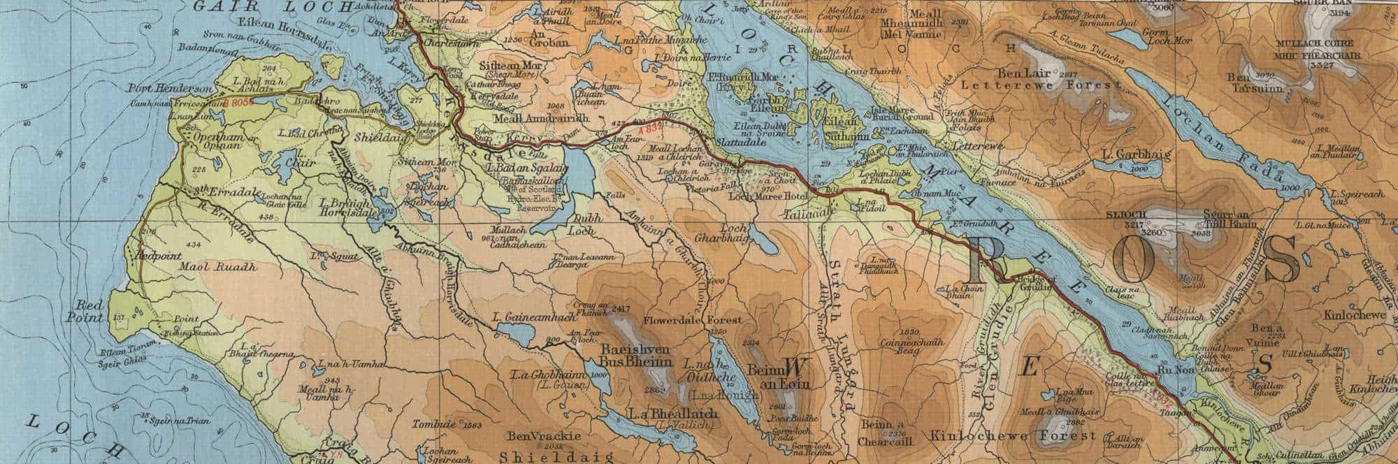
Lochs to the South of Gairloch
Further south there are several very worthwhile fishing lochs. They include Loch Bad an Sgalaig, Dubh Loch, Loch Gharbhaig, Loch na h Oidhche (“Loch of the Night”, a 5 mile walk from the A832 near Loch Bad an Sgalaig – path marked on map below – to reach the boat house at the north end of the loch. A further half hour in the boat will take you to Poca Buidhe, a bothy situated at the south end of the loch. Both the boat and bothy may be hired from the local estate), Loch a Bheallaich, Loch a Ghobhainn, Loch Gaineamhach and the small group of lochs to the south of Badachro and Shieldaig – Loch Bad A’ Crotha, Loch Clair, Loch Braigh Horrisdale and Lochan Sgeireach (known as the “Fairy Lochs”, notable as the crash site of an American World War II bomber). The map below show these and many more, all holding wild trout which may not ever have seen an angler’s fly.
Gairloch South Trout Fishing Map
Tap or click on the map below to view full size image

The maps on this website, extracts from the “Half Inch” Bartholomew map series of the mid twentieth century, have been reproduced with the permission of Collins Bartholomew. Viewers should note that these maps date back several decades, to the mid twentieth century in fact. While much of the man-made details such as roads and buildings will have changed over the years, the character of the hills, lochs and rivers, and the trout inhabiting them, will have remained very much the same as they have always been, in the more remote regions at any rate! This website shows detailed maps of the major fishing locations. In addition, however, I would recommend that anglers planning a Scottish fishing or walking trip should be sure to equip themselves with a compass, the appropriate local Ordnance Survey map and a working knowledge of how to use them. The most useful of the O.S. maps for the fisherman is the Landranger series, scale 1:50,000. For Gairloch, see O.S. map number 19.
For information on the salmon fishing rivers in the area see Salmon Fishing in Scotland